journal

machu-picchu1

machu picchu – prologue
click to read the machu picchu posts


prologue

There have been five destinations that have been out of my comfort-zone. These were – England, Switzerland, Kuala Lumpur, Israel and Sicily.

I hate all things British and to voluntarily go to England was a big step. And still afterwards, none of my misgivings or prejudices needed correcting. Outside of the grand palaces, England was littered with tiny houses and tiny spaces; the highway shoulders were strewn with garbage; the food was terrible; Oxford was a warren; Stonehenge polluted by the car-noise from the A303; and London had none of the grandeur of a Paris or a Rome.
Switzerland was never on my radar, but the trip was a great experience. The place was super clean and the mountains were majestic. We took a gondola up into the Alps and it was truly surreal – going through the clouds, suspended above snow-covered peaks. There’s a famous family-photo of me and Mim, in our matching sweaters, at the restaurant at the top the mountain where the gondola dropped us off. It’s the iconic photo from the trip.
Went to Kuala Lumpur, reluctantly, for an Internet conference. Back then, the Common Knowledge: Pittsburgh project was the only example, world-wide, of school-kids having Internet access. And Rick and I were invited to talk about the Internet in schools. The place was an experience is contrasts – American style highways, American style suburbs, American skyscrapers, American hotels all floating in an equatorial, colonial soup. Whoa!
The Wertheimers took me along on their trip to Israel and it turned out to be one of my favorite places. The country is ethereal, intense, scary, inconsistent. I loved the food; breakfast at the kibbutz was great; the date syrup was worth every calorie. The winds in the Judean desert echoed the music of the spheres; and in Wadi Rumm, we heard the sounds of silence.
If you’re Calabrese and an immigrant, then Sicily is a place to avoid. It’s the land of Mafia. And it’s a people that you, as a Calabrese, are better than. I was 65 by the time I made it to Sicily. What an amazing place. It has a dynamic culture, a creative class, a beautiful landscape. But best of all, is its attitude towards political and Catholic Rome. The Sicilians look northward and raise their middle fingers. How can you not love a people that have blocked every effort to connect their island to the mainland via bridge; that have shuttered over 60% of their churches?

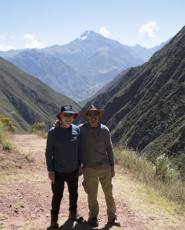
And now, I’m getting ready to add a sixth destination to my list. Bitonti and I are heading to South America, to Peru, to the Sacred Valley of the Incas, to Machu Picchu.

machu-picchu2

machu picchu – maimi
click to read the machu picchu posts


trying to sleep

This morning, American Airlines called Frank’s cell to suggest that we take their 1:00 flight, because the later flight, we were scheduled on, would probably not be flying out – mechanical problems. So, we got it together and headed to Pearson by 10:30.

It’s now 6:00 pm, we’re in the Miami Airport and our flight to Lima doesn’t leave for another 7 hours.

The airport is a sprawling complex and we put in almost a mile walking from the domestic gate where we landed to the international terminal. And the international concord is a Spanish speaking area. Miami is an eastern gateway to Central and South America.

I always bring my phone and tablet charges with me, but it never occurred to me to also have my laptop charger and do some work while I’m waiting for a flight. (I’m just getting used to having WI-FI access at airports.) This is the first post, I wrote at an airport. (Frank is sitting across from me grading papers for his online course-work.)

I couldn’t sit in the uncomfortable chairs any more and just laid down on the floor. That’s the image on the right.

Sitting at the international terminal, I can’t help but think that this morning we left Canada, a country that was part of the British empire; and here we are in Florida and getting ready to go to Peru – a country that was part of the vast Spanish empire.

A side note: Our Miami/Lima flight got posted on the Departures board as delayed an hour. When I went up to the gate-agent to ask, she told me that the flight was on-time and that I should just ignore the board. The agent made an announcement about the on-time departure, but only in Spanish. (The Departure board was never corrected.)

machu-picchu3

machu picchu – day1
click to read the machu picchu posts


11,000 feet

At the Lima airport we met our first VBT-person and he got us from the international terminal to the domestic one to check-in. The airport is extremely busy and having someone direct us was great. We also met the people that we will be traveling with.

At the Cusco airport, the guides took over and all we had to do was get in a small bus for the trip to the hotel. The pic is the courtyard in front of our room.

Cusco is 11,200 feet above sea-level and this is where everyone talks about altitude sickness. So far, I’ve had no reaction to the altitude. Tomorrow, we are descend into the Sacred Valley. Cusco is the highest point we will be at.

The VBT organizers, left today unplanned to give the group a chance to acclimate to both the altitude, weather and to give people traveling on their own time to get to Cusco.

We are in that space between the end of fall and the beginning of winter. So the weather is variable. We went out walking and I’m dressed in long-sleeves and layers. It never occurred to me to put on sun-screen and I can now feel that pre-sunburn tingle on my ears and face.

mach-picchu4

machu picchu – day1
click to read the machu picchu posts


spanish baroque

The main plaza in Cusco, with is magnificent Baroque cathedral, is so like the piazzas in Caltagirone, Catania, Modica, Noto, Ragusa and Scicli – the towns in the Valle di Noto. Both locations are magnificent examples of Spanish Baroque architecture. Here in Cusco, the facades of the convents, churches, basilicas are brown stone; in Sicily it’s the white rock, the tuffa stone, that is everywhere in Italy.

The Spanish, under Francisco Pizarro, with the Battle of Cajamarca in 1532, ambushed and captured Atahualpa – Emperor of the Inca Empire. It was the first step in a long campaign to subdue the mightiest empire in the Americas. To cement their control over the people, the Inca Empire’s central city – Cusco – was rebuild in the Spanish Baroque style.

Frank pointed out that Columbus’ first voyage in 1492 began the Spanish expansion in the Americas. And it would be 100 years before France and England joined the rush to conquer the New World. Imagine, for 100 years, Spain had sole access to the treasures and resources in the Americas.

In the seventeen century, the Spanish ruled the Kingdom of the Two Sicilies. After a devastating earthquake in January of 1693, in south-eastern Sicily, the Spanish sent architects to the region to rebuild the devastated cities in the Baroque style.

machu-picchu5

machu picchu – day2
click to read the machu picchu posts


mother earth

Today, was the first tour-day and the guides took us 30 miles south and east to a rural community in the Urcos region. Community, in this instance, refers to extended families working together for their common good. To reach the community we took the Interoceanic Highway an east-west, two-lane road that spans 1,600 miles from Peru’s Pacific coast, across the Andes, through a large part of the Amazon rain forest and into Brazil where it connects with a network of existing highways ending at the Atlantic.

The Cuyuni community operates a way-station for pilgrims going to the glacier in the adjoining mountain range as well as hosting tourist group like ours. In the above image, the community wise-man and an assistant are performing a ritual to Mother Earth. And the goal of the ritual is to honor and ask Mother Earth for her help with their crops, their animals and their families.

The community is slowly building the tourist side of their business. The tour package included a 2-mile trek through their properties, various ceremonies, a weaving demonstration and lunch. Also, the group is slowly building up a gift-shop that stocks hand-made items that their women have woven. The above image is a table runner I shot while browsing.

A side note: Potatoes were being harvested at various plots in their large holdings. At one point, two community women stopped at a smoldering mound and began to dig into the hot earth uncovering potatoes roasted in the ashes. With their thick roasted skins and natural sweetness they were amazing.

machu-picchu6

machu picchu – day3
click to read the machu picchu posts


3,000 feet down – part one

We began at the top of the mountain in the small town of Chinchero, 12,346 feet above sea-level and followed a section of the Inca Trail down through the valley to the town of Urquillo on the valley floor. During the 4-hour trek, we walked 9 miles along the remains of the ancient Inca Trail. In places, the steps were totally gone and you were slowly going down the slope that remained.

The ancient trail hugged the side of the mountain and in 4 hours, we dropped 3,000 feet.

You would think that going downhill should make hiking easier, but downhill places particular demands on knees and hips.

This was a very strenuous trek, made difficult by rock-covered slopes. We all used two walking-poles for stability and to minimize sliding down.

In the above image, we are at the beginning of the trail; and you can still see the walls that the Incas built, along the side of the mountain, to hold the trail-path.

machu-picchu7

machu picchu – day3
click to read the machu picchu posts


3,000 feet down – part two

Halfway down and we reach a flat area and we all took pictures with the snow-capped mountain in the background.

Frank brought the hat with him; I quickly discovered that my ball-cap didn’t keep the equatorial sun off my nose or ears, so I had to buy a hat with a brim. (It will not come back to Pittsburgh.)

What I really wanted was a stovetop hat like the locals wear, but I was told that those are not sold at the tourist markets. 
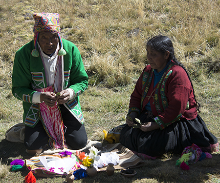
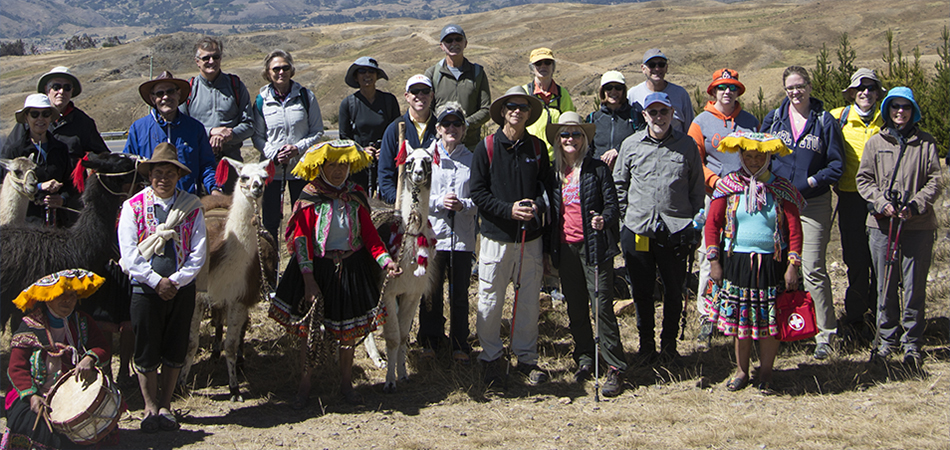
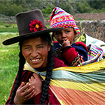
Apparently, each town or district still has its own hat-maker and he makes the unique hats for the people of his community. The unique hats designate what section, of the area, a person is from. (I didn’t need it to have a flower.)

The other discovery was that winter in equatorial Peru is a misnomer. It is cold after the sun goes down and in the morning for a couple of hours, but for most of the day the weather is mild. I should have brought lighter pants and more T-shirts.

machu-picchu8

machu picchu – day4
click to read the machu picchu posts


the market – part one

We began the day by going to the sprawling Qotowincho Market in central Urubamba, the largest town in the Sacred Valley. The market has everything from gladiolas to guinea-pigs. In Peru, guinea-pigs are a food, not pets. (Yesterday, at the corn-beer tasting, the hosting family served roasted guinea-pigs. I passed. How can I eat an animal that Connie and Danny had as a pet?)

The market is all local products grown in the surrounding cooperatives. There were sacks of fava; potatoes took up all of the northern stalls; squash filled a whole aisle. The market showed how, at the equator, the growing season is year-round; fava, a spring crop, and winter squash, were being sold side-by-side.

The animal vendors had guinea-pigs, ducks, piglets, rabbits, chickens, and sheep. And only the American tourists were oohing and ahhing the baby animals; the locals were dragging piglets and chickens into their trucks. (I asked our tour-guide what the bundles of green reeds that everyone seemed to be carrying were. He explained that they were food for guinea-pigs. Every family keeps guinea-pigs and they fatten them up before cooking them.)

machu-picchu9

machu picchu – day4
click to read the machu picchu posts


cooperatives – part two

After the market, we drove up to the small town of Maras – 11,082 feet above sea-level – to begin our hike to the salt flats. We walked through a large, rather flat, farming area at the top of the mountain. Our guides kept reminding us that the area was farmed collectively by a number of the surrounding communities. (In the Andes, the notion of working collectively is not an ideology, it’s an economic and social necessity when living in such a steep and rugged environment.)

When my mother asked what Peru was like, I answered, “Like Calabria 80 years ago.” Her comment was, “So, you’re saying that the people are poor and that they live interdependently.” The tour-guide suggested that this interdependence makes for a less aggressive and more cooperative personality. And therefore more welcoming and accommodating of tourists. (The locals are nothing like the snooty French or the disdainful Italians I’ve dealt with on other trips.)

machu-picchu10

machu picchu – day4
click to read the machu picchu posts


salt flats – part three

The salt flats are another cooperative effort of the communities around Maras Town.

There is a huge salt deposit under the mountains in this area and subterranean streams carry the salt to the surface. The flow is directed into an intricate system of tiny channels constructed so that the water runs gradually down onto the terraced ponds. (This aqueduct system is like a giant spider web stretched over the salt-flats.) Each pond is about 40 square feet and only 11 inches deep. There are some 700 shallow ponds and maintenance of the feeder channels, the side walls, the water-entry notch, the bottom surface, the quantity of water, and the removal of the salt deposits requires close cooperation among the families and communities that own the flats. Locals and pond workers say that the cooperative system was established during the time of the Incas, if not earlier.

As the water evaporates what’s left behind are huge deposits of salt. The top layer of the salt-flat is harvested and used for the animals, the middle layer is used by the community and the bottom layer, the desirable pink salt, is sold to the tourists.

In a valley perimetered by rugged peaks, a set of cascading ridges, covered with shallow salt-water pools and made white by evaporation, create a prehistoric landscape.

machu-picchu11

machu picchu – day5
click to read the machu picchu posts


getting to the ruins

The logistics of getting to the ruins at Machu Picchu were not clear in the travel packet. All I focused on, was the need to bring a secondary bag that would server as my luggage when we went to Machu Picchu. (It was only after talking to Allie at VBT that I understood the need for a “carry-on” size bag that I packed a backpack.)

Access to the Inca ruins at Machu Picchu is strictly controlled by the Peruvian Government.

VBT interfaced with the government agency managing Machu Picchu to secure all the needed tickets.

The only way to get to the ruins at Machu Picchu is by PeruRail. And luggage size and weight are heavily restricted.

We left from Ollantaytambo Train Station early in the morning. We stored our small bags in the narrow space between the seats. And even though luggage size is restricted, service on the two-car train was like service on a trans-Atlantic flight. It was amazing.

The trip takes about an hour-and-a-half. The tracks follow the sacred Urubamba River – the reflection of the Milky Way here on earth. The train stops twice; once, to let off hikers who are doing the 4-day hike to the ruins; and a second time to let off hikers who are doing the 6-hour hike.

The majority of our group got off at marker Km104 for the 6-hour hike up the Inca Trail to the ruins. Ann, Don and I passed on the hike.
 

The final stop is Aguas Calientes. This small town services, accommodates and transports the thousands who come to see the ruins.

The whole town is about tourism. Near the railroad station are all the hotels, hostels and other accommodations. To get to our hotel – Inkaterra, Machu Picchu – we walked through the warrens that are the souvenir stalls. The hotel porters lugged all the luggage from the train station to the hotel on flat-bed carts that they push up the steep inclines.

There are no private vehicles in Aguas Calientes. To get to the ruins, you board a bus in town and for an hour you ascent the mountain on a one lane, gravel road.

It was both amazing and nerve-racking when two buses had to negotiate the right-of-way. Only the corners, on the switch-back road, were paved with stones otherwise we were on a dusty dirt road.

machu-picchu11a

machu picchu – day5
click to read the machu picchu posts


the ruins from afar

Ann, Don and I opted to not do the 6-hour hike, following the Inca Trail up Machu Picchu mountain. Instead we went up to the ruins on the shuttle bus. (Sergio, one of our guides, came with us.) We walked the Inca Trail from the ruins up to the Sun Gate.

The image is somewhat deceptive, because the ruins are quite far away from where Sergio took the shot. We are standing on a small plateau south of the ruins. (The small plateau is part of Machu Picchu Mountain.) From this distance, the ruins, the smaller mountain look like a set; it’s hard to get a sense of the size of the settlement, the size of the various structures from this far away. But as a backdrop the whole thing is amazing, right?

The peak behind us was at one time part of Machu Picchu Mountain. The earthquake that split the mountain left an area in-between relatively workable and it’s on this in-between outcrop that the Incas build the settlement.

Also, at the top of the peak, behind us, is an Inca observation station that can be reached from steps along the side of the mountain. Jorge, our other guide, said that when he was a teenager, the rage among he and his friends was to see who could reach the observation station in the shortest time. He made it up the mountain in 16 minutes. However, it became such a draw that people began to do very risky and dangerous antics to get to the top. The Government now restricts access to the peak and you have to make an appointment and be approved to go up. You also have to sign all sorts of waivers promising to not hold the Government liable for any harm that comes to you while making the steep climb.

machu-picchu12

machu picchu – day6
click to read the machu picchu posts


how do you write about extraordinary

Yesterday, seeing the ruins from the southern plateau did not prepare me for the experience of walking into the settlement.

The ruins of Machu Picchu require a rethinking of South America.

For many in the US, with its English Empire legacy, South America is seen as less than. American culture still holds on to those British prejudices towards southern people, towards people who are not English speaking, towards people who have dark skin.

And yet in Mach Picchu we are presented with indisputable evidence of a great culture, a society of scientists, mathematicians and astronomers; scientists who were breeding plants and animals for high altitudes; mathematicians who were using zero; astronomers who tracked the sun and the moon and believed the earth was round. (The astronomers were looking at the heavens through small reflecting pools found throughout the ruins. They were looking at reflections and had to convert what they saw back to a non-reflection.)
 
 
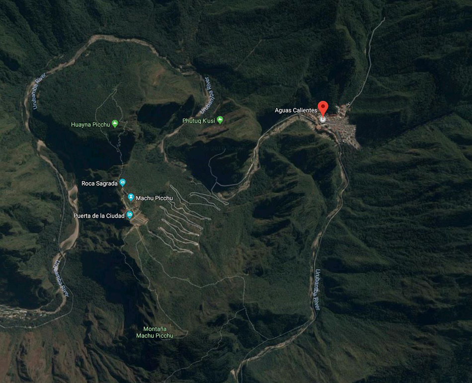
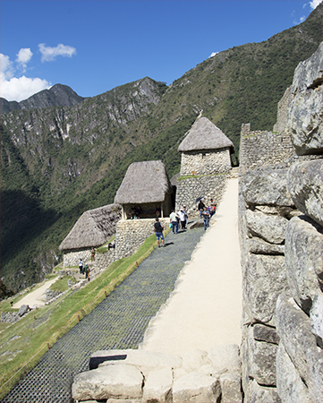
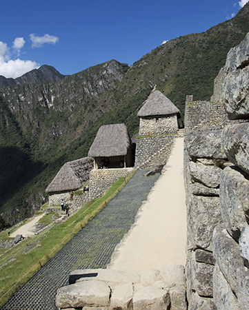
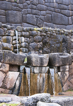
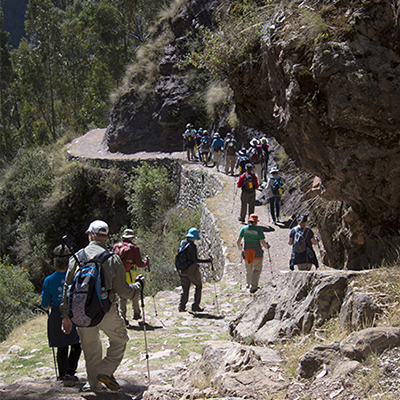
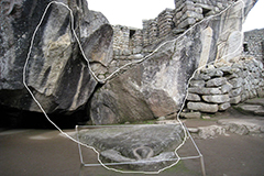
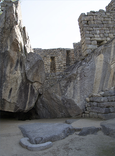
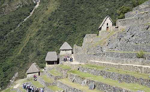
The ruins take their name from the mountain – Machu Picchu; no one knows what the Incas called the settlement, because there are no written accounts.

The Peruvian Government that manages the ruins, has roofed a number of the structures to show how they would have looked when people were living in the settlement. Both images are looking at the southern edge of the ruins; in the top pic I’m standing on the terrace directly in front of me. The bottom image, taken from the across the valley, shows the terraces that climb the side of the mountain.

In both images, I removed some of the people to give a better idea of the landscape and the ruins.

machu-picchu13

machu picchu – day6
click to read the machu picchu posts


water

The settlement has a network of water troughs, pipes, and fountains that distribute the water the Incas channeled from the mountain streams in the vicinity. There’s even an underground sewage system that uses water to bring the waste out of the settlement and dumps it onto the agricultural terraces or over the mountain side.

The water story began on Tuesday when we entered the Sacred Valley. The valley is formed by the Urubamba or Sacred River. In the heartland of the Inca Empire, the Sacred Valley was the most important area for maize production; the valley also facilitated the import of products such as coca leaf and chili peppers from the tropical areas in the north and east. The valley was the main commerce channel to the empire’s capital at Cusco.

The Incas believed that the Urubamba River was a reflection of the Milky Way on earth. The Milky Way1 – the Mayu – was believed to be a river and the source of all water on earth. And since earth and sky are connected the Sacred River was the reflection of the celestial river.

1The Milky Way a barred spiral galaxy with roughly 400 billion stars appears like a band of light in the night sky. The galaxy stretches between 100,000 to 120,000 light-years in diameter.

machu-picchu14

machu picchu – day6
click to read the machu picchu posts


the temple of the condor

In Inca mythology, the condor ruled the sky, the puma the earth and the snake the underworld.

The Temple of the Condor at Machu Picchu is a very small space in the south-east section of the settlement. The space is dominated by a massive abstract representation of a condor, its outstretched wings carved onto pre-existing slabs of stone.

On the floor of the temple is a rock carved in the shape of the condor’s head and neck feathers, completing the figure of a three-dimensional bird. Historians speculate that the head of the condor was used as a sacrificial altar.

Under the temple is a small cave that originally contained a mummy. Also, there’s a prison complex directly behind the temple comprised of human-sized niches and an underground maze of dungeons. According to historical chronicles that documented similar Inca prison sites, an accused citizen would be shackled into the niches for up to 3 days to await deliberation. He could be put to death for such sins as laziness, lust, or theft.

Throughout the settlement we saw example of where the Inca incorporated pre-existing slabs, outcrops or boulders into walls, stairs, floors. In the Temple of the Condor, the use of two gigantic slabs to represent the condor’s outstretched wings was the most spectacular.

This was the last location we entered before we made our way out of the ruins. By then we were all tired and the place was emptying out, so my options for finding a location to shoot this massive abstract were limited. It was the one time I regretted not bringing a wide-angle lens. To shoot the pic and to get any semblance of the wings, I had to press flat against the outside temple wall.

(I found the image on the left online. It gives a better idea of the outline of the condor and the massive slabs that form its wings. The low rock-wall on the right is an entrance into the temple.)
 

machu-picchu15

machu picchu – day7
click to read the machu picchu posts


back in cusco

We were back at the train station in Aguas Calientes Town for our trip back to Ollantaytambo. The service was again spectacular, but this time the agents added a fashion-show. They modeled various alpaca clothing that you could buy. (It was quite strange and funny.)

From Ollantaytambo we got back onto the VBT bus for the ride back to Cusco. Between the train and the bus, we were sitting for almost 5 hours.

The trip into Cusco was very different than the trip from the airport. We came in from the north-west and at various points we saw the city laid out in the valley. Cusco has 600,000 residents and for the first time from various viewpoints we saw the whole city spread out through the valley and up the slopes.

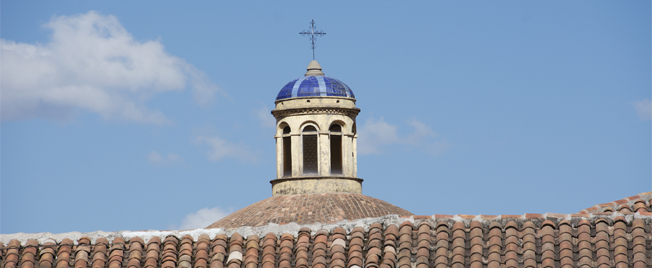
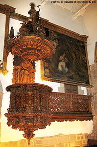
We got dropped off in the artisan section and we walked the narrow cobblestone streets of the old city to San Blas church. The attraction in the church was an elaborately carved pulpit. The Archdiocese in Lima has ruled that no photographs are allowed in any church. The image on the left is from online and from a time when you could take photographs inside a church. (The story the guide told us is that the Archdiocese is afraid thieves will come and steal the valuable artifacts if they are photographed and put where anybody and everybody can see the treasured housed in the Peruvian churches.)

San Blas was another over-the-top Spanish Baroque church. I haven’t liked any church I’ve seen. Everything is over-decorated, everything looks oppressive, extreme, gaudy, unrecognizable. Yes, the pulpit required a master carver. But Oh my God what happened to simple lines? What happened to form and function? It seems it’s all made to overwhelm to overpower.

A side note: According to tradition, while Blas/Blaise was being taken into custody, a distraught mother, whose only child was choking on a fishbone, threw herself at his feet and implored his intercession. Touched at her grief, he offered up his prayers, and the child was cured.

On the feast-day of St. Blaise – February 3, the priest holds two burning candles in a crossed position over your head or on either side of your throat and gives the following blessing: “May Almighty God at the intercession of St. Blaise, Bishop and Martyr, preserve you from infections of the throat and from all other afflictions”. This is supposed to keep you infection free for a year. (Note: You need to renew your blessing annually.)

machu-picchu16

machu picchu – day8
click to read the machu picchu posts


our last day

The only day we had rain was our last day in Cusco. That didn’t deter anyone from donning our rain gear and heading out.

We began the morning at the fortress of Sacsayhuaman on a hilltop above the city. What is incredible is to see are the various megaliths that make up the walls; some weigh between 90 and 130 tons and they are amazing in their precision – cuts and fits. The site also has a large ceremonial plaza that was still used for re-enactments on the winter solstice.

And the vistas of Cusco from this vantage point were great – terra-cotta tiles filling an Andean valley. In Cusco, you are never far from Catholic symbols. On this mountain top, on an eastern promontory was a tall white statue of Jesus and on a western outcrop a huge wooden cross. The tiled rooftops below us made you forget the religious intruders.

My favorite part of the walk were the fountains and aqueducts at Tambomachay. The image on the right captures three of the fountains. The stone work and the masonry on the top wall are as good as any laser cuts and modern construction. And lets not forget that it was all done with relatively rudimentary tools.

Tomorrow morning we leave for the airport at Cusco and from there to Lima. Because of the long layover in Lima, VBT has reserved hotel rooms for us. And this time the layover in Miami is only 6 hours – Oh joy!

machu-picchu17

machu picchu – epilogue
click to read the machu picchu posts


our group

L to R and B to F   don, ann, frank, bill, jane, tina, larry, tim, linda, kathleen, rick, meredith, rochelle, wayne, mario, ann, sarah, pete, barb
missing from the picture are our guides sergio and jorge
 
the four people in traditional clothing are cuyuni community members – the image was taken on monday, may 28